USGS Contour Map
of OBG [click below]
[click below]
![[U.S. Geographical Survey
Map of General Separations Area at SRS.]](../GIF/USGS_large.gif)
![[Aerial photo of OBG
site at SRS.]](http://www.math.sc.edu/~sharpley/GIF/OBG_photo.gif)
The Savannah River Site (SRS) has a number of waste sites that will require groundwater modeling to fulfill regulatory requirements. In a collaborative effort with Drs. John Haslow, Larry Hamm, and Gregory Flach of the Environmental Sciences Section of SRS's Technology Center, and Professor James Brannan of Clemson University, modeling efforts have been performed on selected sites to test the performance of the PICS suite of codes and numerical algorithms. This involved data assimilation and geostatistical work to provide realistic model parameters and leveraged off ongoing work at SRS. Three particular waste sites, for which a substantial groundwater modeling effort has now been extended, have been selected for use with the PICS GCT code series. These waste sites are the F-Area and H-Area Seepage Basins and the Old Burial Ground, all of which are in the General Seperations Area of the Savannah River Site.
USGS Contour Map of OBG [click below] |
Aerial Photo of OBG [click below] |
|
|
|
The Seepage Basins received low-level liquid radioactive waste until
1988. The liquid waste discharged to the F\&H Area Basins was acidic
(pH 3-4) and the predominant contaminants were tritiated water (tritium),
nitrate (from nitric acid), and some heavy metals such as lead and cadmium.
The Old Burial Ground (OBG) was used from the middle 1950's until 1972
for the disposal of solid waste. The predominant contaminants that emanate
from the OBG are tritium and volatile organic compounds, and to a lesser
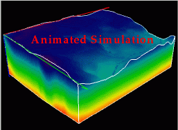
extent heavy metals. The following image and QuickTime movie are rendered
from a simulation of hydraulic pressure with more than one
million computational cells using 128 processors on ORNL's xps35.
| Model formulation (with geological units)[click below] |
Simulation of unsteady pressure field and water table. [click below] |
![[Simulation of pressure field beneath the
OBG with indicated water table, aquifers, and aquitards]](../GIF/SRS.gif)
|
|
The pressures are color-coded according to values with blue denoting negative pressures in the vadose zone, and red corresponding to the highest pressures in the saturated zone.
Each site presents its own engineering and scientific, as well as computational challenges. At the Seepage Basin Sites, the pH of the groundwater is becoming more neutral as the system is naturally flushed by rainwater recharge, requiring geochemical reactions to be accurately accomodated for the effectively simulation of the movement of the heavy metals in the subsurface. At the OBG it is important to simulate the mass transfer of tritium from the solid phase to the groundwater in the vadose zone in order to effectively simulate the system. Representative of the complexity of the heterogeneities of the subsurface environment at OBG is the following three-dimensional geophysical interpretation of mud fraction, defined as clay and silt (as opposed to sand and gravel):
![[lithographic image of Old Burial
Ground]](../GIF/mud_fraction.gif)